The aim of this page is to recognise, celebrate and encourage the self-empowerment of community agency networks (CANs) and community groups across East Sussex.

 ‘Give nature space and it will come back’: rewilding returns endangered species to UK’s south coast, theguardian.com (Jun 27, 2024)
Networks and sustainability initiatives[edit | edit source]
- Green Transition Crowborough, community organisation promoting local action to address climate change and encourage sustainability. added 08:08, 29 April 2024 (UTC)
- Seaford Environmental Alliance, added 17:45, 23 June 2021 (UTC)
- Common Treasury of Adaptable Ideas, commontreasury.org.uk, Hastings, added 17:54, 11 February 2021 (UTC)
- Transition Town Hastings, Community garden, Sustainability on Sea festival, Sustainability on Sea (SOS) 2019, added 16:40, 22 July 2020 (UTC)
- Lewes 2030, a project involving Transition Town Lewes and starting September 2015
- Transition Rye
- Transition Town Lewes
- Village Connections, based around Lewes and surrounding villages
Community resources[edit | edit source]

- Hastings Commons, "take derelict and difficult buildings around the White Rock area of Hastings into community custody, transforming them into social spaces, homes and workspaces that will always be affordable and open to all." added 16:37, 26 September 2023 (UTC)
- East Sussex Community Information Service
- Tablehurst and Plaw Hatch Community Farm, Community landtrust
Climate action[edit | edit source]
- Lewes Climate Hub, "not-for-profit alliance of community groups in and around Lewes in East Sussex, taking action on climate change and ecological breakdown." added 15:24, 10 May 2021 (UTC)
Extinction Rebellion Hastings & St Leonards
Climate emergency centres[edit | edit source]
- Seaford Environmental Alliance, added 17:45, 23 June 2021 (UTC)
Ecosystem retoration[edit | edit source]
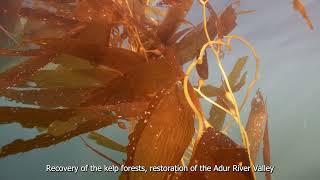
- Sussex Bay, vision: "100 miles of coastline where our seascape and rivers flourish. A healthy blue ecosystem in which nature, people and local economy can thrive." Video: Sussex Bay - official channel on youtube.com
Biodiversity[edit | edit source]
Sussex Wildlife Trust[edit | edit source]
The Sussex Wildlife Trust (SWT) is a conservation charity which aims to protect natural life in Sussex. It was founded in 1961 and is one of 46 wildlife trusts across the UK and the Isle of Man and Alderney. As of 2019, it has 33,000 members and manages 2,000 hectares (5,000 acres) of land for nature. It is a registered charity and in the year to 31 March 2019 it had an income of £5.7 million and expenditure of £4 million, resulting in net income of £1.7 million.
The SWT manages twenty-six nature reserves in the county. Nineteen are Sites of Special Scientific Interest, one is a national nature reserve, eleven are local nature reserves, eight are Special Areas of Conservation, three are Special Protection Areas, three are Ramsar sites and seven are Nature Conservation Review sites. Its headquarters at Woods Mill, south of Henfield, is also a nature reserve with a lake, woodland and meadows.
The historic county of Sussex is divided into the administrative counties of East Sussex and West Sussex. The South Downs stretches across the county from west to east. This area is chalk and to the north is the Weald, which is composed of heavy clays and sand. The coast has a succession of holiday towns such as Brighton, Eastbourne, Bognor Regis and Worthing.
Other initiatives[edit | edit source]
Rye Harbour Nature Reserve - Sussex Wetland Landscapes Project -
Open spaces[edit | edit source]
The South Downs National Park is England's newest national park, designated on 31 March 2010. The park, covering an area of 1,627 square kilometres (628 sq mi) in southern England, stretches for 140 kilometres (87 mi) from Winchester in the west to Eastbourne in the east through the counties of Hampshire, West Sussex and East Sussex. The national park covers the chalk hills of the South Downs (which on the English Channel coast form the white cliffs of the Seven Sisters and Beachy Head) and a substantial part of a separate physiographic region, the western Weald, with its heavily wooded sandstone and clay hills and vales. The South Downs Way spans the entire length of the park and is the only National Trail that lies wholly within a national park.
The idea of a South Downs National Park originated in the 1920s, when public concern was mounting about increasing threats to the beautiful downland environment, particularly the impact of indiscriminate speculative housing development on the eastern Sussex Downs (Peacehaven was an example of this). In 1929, the Council for the Preservation of Rural England, led by campaigners including the geographer Vaughan Cornish, submitted a memorandum to the Prime Minister urging the case for national parks, including a national park on part of the South Downs. When however, towards the end of World War II, John Dower was asked to report on how a system of national parks in England and Wales might be established, his 1945 report, National Parks in England and Wales, did not identify the South Downs for national park status, but rather included it in a list of "other amenity areas". Sir Arthur Hobhouse's 1947 Report of the National Parks Committee took a different view, and he included the South Downs in his list of twelve areas recommended for designation as a national park, defined by John Dower as an "extensive area of beautiful and relatively wild country in which, for the nation's benefit...the characteristic landscape beauty is strictly preserved".
The South Downs was the last of the original twelve recommended national parks to be designated. Extensive damage to the chalk downland from 1940 onwards through arable farming, and a resulting decline in sheep grazing, militated at an early stage against further work on designation. When in 1956 the National Parks Commission came to consider the case for the South Downs as a national park, it found designation no longer appropriate, noting that the value of the South Downs as a potential national park had been reduced by cultivation. It did however recognise the "great natural beauty" of the area, and proposed it be designated as an Area of Outstanding Natural Beauty. In due course two AONBs were designated, split along the county boundary, namely the East Hampshire AONB in 1962 and the Sussex Downs AONB in 1966. These were later to form the basis of the South Downs National Park.
In September 1999 the government, following a review of national parks policy, declared support for a South Downs National Park, and announced a consultation on its creation. In January 2003 the then Countryside Agency (now Natural England) made an Order to designate the proposed park in 2003 which was submitted to the Secretary of State for the Environment on 27 January 2003.
As a result of objections and representations received on the proposed Order, a public inquiry was conducted between 10 November 2003 and 23 March 2005, with the aim of recommending to ministers whether a national park should be confirmed and, if so, where its boundaries should be. The results of the inquiry were expected by the end of 2005, but were delayed pending a legal issue arising from a High Court case challenging part of the Order designating the New Forest National Park.
Following an appeal on the High Court case and new legislation included in the Natural Environment and Rural Communities Act 2006, the South Downs Inquiry report was published on 31 March 2006. It recommended a 23% reduction in the size of the originally proposed national park, focussing it more narrowly on the chalk downland and excluding from it a large part of the existing East Hampshire and Sussex Downs AONBs. This proved highly controversial, leading to calls from the Campaign for the Protection of Rural England and others for the inclusion of the so-called western Weald, a region within the two AONBs possessing a geology, ecology and landscape quite different from the chalk hills of the South Downs, within the park boundary to ensure that it remained protected from development. The Secretary of State invited objections and representations on new issues relating to the proposed national park in a consultation that ran from 2 July to 13 August 2007. In the light of the responses received, the Secretary of State decided that it was appropriate to re-open the 2003–05 public inquiry. The inquiry re-opened on 12 February 2008 and was closed on 4 July 2008 after 27 sitting days. The Inspector's report was submitted on 28 November 2008.
On 31 March 2009 the result of the inquiry was published. The Secretary of State, Hilary Benn, announced that the South Downs would be designated a national park, and on 12 November 2009 he signed the order confirming the designation. He confirmed that a number of hotly disputed areas – including the western Weald, the town of Lewes and the village of Ditchling – would be included within the national park.
The new national park came into full operation on 1 April 2011 when the new South Downs National Park Authority assumed statutory responsibility for it. The occasion was marked by an opening ceremony which took place in the market square of Petersfield, a town situated in the western Weald just 4 km (2.5 mi) north of the chalk escarpment of the South Downs.
In 2016 the national park was granted International Dark Sky Reserve status, to restrict artificial light pollution above the park. It was the second such area in England and the 11th in the world.
The national park is administered by the South Downs National Park Authority (SDNPA). The SDNPA was established on 1 April 2010, and became fully functioning, including becoming the planning authority for the national park, on 1 April 2011. It is responsible for promoting the statutory purposes of the national park and the interests of the people who live and work within it. The statutory purposes of the SDNPA, as a national park authority, are specified by the Environment Act 1995; these are:
- To conserve and enhance the natural beauty, wildlife and cultural heritage of the area
- To promote opportunities for the understanding and enjoyment of the Park's special qualities by the public.
It must also fulfil the following duty:
- In carrying out its role, the authority has a duty to seek to foster the economic and social well-being of the communities living within the national park.
The SDNPA is a public body, funded by central government, and run by a board of twenty seven members. The board consists of seven national members, appointed by the environment secretary by means of an open recruitment process; fourteen local authority nominees drawn from the fifteen local authorities covering the park area with Adur and Worthing opting to share a place; and six parish council representatives, two for each county.
As at June 2024, the chair of SDNPA is Vanessa Rowlands, and the chief executive (interim) is Tim Slaney.
The South Downs National Park stretches for 140 km (87 mi) across southern England from St Catherine's Hill near Winchester in Hampshire in the west to Beachy Head, near Eastbourne in East Sussex in the east. In its western half, the southern boundary of the park lies up to 10 km (6.2 mi) inland from the south coast; it thus excludes the major coastal towns and cities of Southampton, Portsmouth, Chichester, Bognor Regis and Littlehampton. Further east, where the park's southern boundary lies much closer to the coast, it has been carefully drawn to exclude the urban areas of Worthing, Brighton and Hove, Newhaven, Seaford and Eastbourne, which had all made substantial encroachments onto the Downs during the 19th and 20th centuries. By contrast, the park includes a number of towns situated in the western Weald, including Petersfield, Liss, Midhurst and Petworth, and the two historic Sussex towns of Arundel and Lewes.
The total population living within the national park is approximately 108,000. Of these 42,000 live in Hampshire, 40,000 in West Sussex and 25,000 in East Sussex. East Hampshire District Council area and Chichester District each have around 30,000 residents in the area and Lewes District 22,000. Winchester has 11,500 residents in the park, with much smaller numbers for the other districts and boroughs. The area receives about 39 million visits each year, which is thought likely to increase as a result of the creation of the national park.
The national park has an area of 1,625 km2 (627 sq mi), of which 544 km2 (210 sq mi) is in Hampshire, 807 km2 (312 sq mi) in West Sussex and 237 km2 (92 sq mi) in East Sussex. Among the district council areas, Chichester District has the largest area at 544 km2 (210 sq mi), followed by East Hampshire District with 279 km2 (108 sq mi), Winchester with 265 km2 (102 sq mi), Lewes District with 159 km2 (61 sq mi) and Arun 102 km2 (39 sq mi). 93 km2 (36 sq mi) are in Horsham District and 60 km2 (23 sq mi) in Wealden District.
Apart from a number of boundary revisions, the park incorporates two areas previously designated as Areas of Outstanding Natural Beauty, the East Hampshire AONB and Sussex Downs AONB. The park also includes the Queen Elizabeth Country Park near Petersfield.
The South Downs National Park's chalk downland sets it apart from other national parks in Britain. However, almost a quarter (23%) of the national park consists of a quite different and strongly contrasting physiographic region, the western Weald, whose densely wooded hills and vales are based on an older Wealden geology of resistant sandstones and softer clays. The highest point in the national park, Blackdown, at 280 m (919 ft) above sea level, is in fact situated in the Weald, on the Greensand Ridge, whereas the highest point on the chalk escarpment of the South Downs, Butser Hill, has an elevation of 271 m (889 ft) above sea level.
Within the national park there are two chalk hill figures, the Litlington White Horse and the Long Man of Wilmington.
Most of the national park consists of chalk downland, although a significant part consists of the sandstones and clays of the western Weald, a strongly contrasting and distinctive landscape of densely wooded hills and vales.
The chalk was formed in the Late Cretaceous epoch, between 100 million and 66 million years ago, when the area was under the sea. During the Cenozoic era the chalk was uplifted as part of the Weald uplift which created the great Weald-Artois Anticline, caused by the same orogenic movements that created the Alps. The relatively resistant chalk rock has, through weathering, resulted in a classic cuesta landform, with a northward-facing chalk escarpment that rises dramatically above the low-lying vales of the Low Weald.
The chalk escarpment reaches the English Channel west of Eastbourne, where it forms the dramatic white cliffs of Beachy Head, the Seven Sisters and Seaford Head. These cliffs were formed after the end of the last ice age, when sea levels rose and the English Channel was formed, resulting in under-cutting of the chalk by the sea.
The South Downs run linearly west-north-westwards from the Eastbourne area through southern Sussex to the Hampshire downs, separating the south coastal plain from the clays and sandstones of the Weald. Behind the escarpment, on the dip slope, are the characteristic high, smooth, rolling downland hills interrupted by dry valleys and wind gaps, and the major river gaps of the Cuckmere, Ouse, Adur and Arun.
The chalk is a white sedimentary rock, notably homogeneous and fine-grained, and very permeable. It consists of minute calcite plates (coccoliths) shed from micro-organisms called coccolithophores. The strata include numerous layers of flint nodules, which have been widely exploited as a material for manufacture of stone tools as well as a building material for dwellings. Similar areas in Britain include the North Downs and the Chilterns.
In its western section, the national park extends north beyond the chalk escarpment of the South Downs into a quite different and strongly contrasting physiographic region, the western Weald, taking in the valley of the western River Rother, incised into Lower Greensand bedrock, and the densely wooded hills and valleys of the Greensand Ridge and Weald Clay south of Haslemere.
- Wiston House
- Butser Ancient Farm
- National Park Authority website
- Links to detailed Defra maps of the confirmed boundary, archived in 2010
- Visit South Downs
- South Downs Trust
Coastal community activism[edit | edit source]
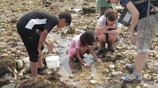
- Wild Coast Sussex, sussexwildlifetrust.org.uk/
- Sussex Kelp Restoration Project, sussexwildlifetrust.org.uk
Community involvement[edit | edit source]
Democracy4Bexhill, Campaigning for a town council added 18:00, 10 March 2020 (UTC)
Community currencies activism[edit | edit source]
Community energy[edit | edit source]
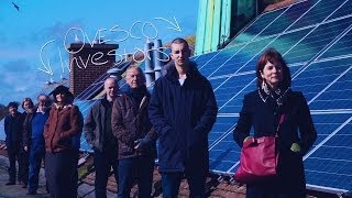
OVESCo, set up in 2007 by four people who meet through the Transition Town Lewes Energy Group. OVESCo has run the Lewes District Council renewables grant scheme since September 2007 and helped over one hundred homes install solar thermal panels, wood burning stoves, GSHP's, biomass boilers and PV panels. The company is working to convert to an Industrial and Provident Society so that the Lewes District Community can invest in renewable power generation projects. W
Food activism[edit | edit source]
Pevensey & Westham Community Forest Garden, pawforestgarden.co.uk, local people growing food in a sustainable way that allows wildlife to flourish too. Volunteers have created clearings for beehives, planted many fruit and nut trees, created a herb garden, built a wildlife pond, and run community workshops. added 17:09, 21 October 2021 (UTC)
Housing and land[edit | edit source]

- Sussex Community Housing Hub, established to provide essential support for communities across Sussex wishing to pursue successful community led housing projects. 'added 16:18, 17 December 2021 (UTC)
See also: Towards a more democratic and climate friendly way of meeting housing need across England, Housing UK news
Reduce, reuse, repair and recycle[edit | edit source]
- Seaford Repair Cafe, added 16:58, 13 October 2021 (UTC)
Sustainable transport activism[edit | edit source]
Among the long-distance footpaths in East Sussex are the South Downs Way; 1066 Country Walk, High Weald Landscape Trail, Saxon Shore Way, Sussex Border Path, Sussex Ouse Valley Way, Vanguard Way, Wealdway and The Monarch's Way.
East Sussex is a ceremonial county in South East England. It is bordered by Kent to the north-east, West Sussex to the west, Surrey to the north-west, and the English Channel to the south. The largest settlement is the city of Brighton and Hove, and the county town is Lewes.
The county has an area of 1,792 km2 (692 sq mi) and a population of 822,947. The latter is largely concentrated along the coast, where the largest settlements are located: Brighton and Hove (277,105), Eastbourne (99,180), and Hastings (91,490). The centre and north of the county are largely rural, and the largest settlement is Crowborough (21,990). For local government purposes, East Sussex comprises a non-metropolitan county, with five districts, and the unitary authority of Brighton and Hove. East Sussex and West Sussex historically formed a single county, Sussex.
The north-east of East Sussex is part of the Weald, a sandstone anticline that was once an extensive woodland. The highest point in this area is Crowborough Hill (242 m (794 ft)), part of the High Weald uplands. The south-west of the county is part of the South Downs, a rolling chalk escarpment that stretches west into West Sussex and Hampshire. Ditchling Beacon (248 m (814 ft)) is the highest point. Where the downs reach the sea, they form high cliffs such as the Seven Sisters, where eroded dry valleys create an undulating skyline. The county does not contain large rivers, but its largest are the Rother, which forms part of the boundary with Kent, the Cuckmere, and the Ouse, which rises in West Sussex and flows through Lewes before reaching the English Channel at Newhaven.
East Sussex is part of the historic county of Sussex, which has its roots in the ancient kingdom of the South Saxons, who established themselves there in the 5th century AD, after the departure of the Romans. Archaeological remains are plentiful, especially in the upland areas. The area's position on the coast has also meant that there were many invaders, including the Romans and later the Normans, following the defeat of the English army by William the Conquerer at the Battle of Hastings in 1066. Earlier industries included fishing, iron-making, and the wool trade, all of which have declined or been lost completely.
Sussex was historically sub-divided into six rapes. From the 12th century the three eastern rapes together and the three western rapes together had separate quarter sessions, with the county town of the three eastern rapes being Lewes. This situation was formalised by Parliament in 1865, and the two parts were made into administrative counties, each with its own elected county council in 1889 under the Local Government Act 1888. In East Sussex there were also three self-administered county boroughs: Brighton, Eastbourne and Hastings.
Upon its foundation, East Sussex included the south of Tunbridge Wells and the south of Lamberhurst; by the Local Government Act 1894 these areas were transferred to Kent.
In 1974 East Sussex was made a non-metropolitan and ceremonial county, and the three county boroughs became districts within the county. At the same time the western boundary was altered, so that the Mid Sussex region (including Burgess Hill and Haywards Heath) was transferred to the non metropolitan county of West Sussex. In 1997, Brighton and Hove became a self-administered unitary authority; it was granted city status in 2000, whilst remaining part of the ceremonial county of East Sussex.
The area of East Sussex County Council's jurisdiction is divided into five local government districts. Three are large rural districts (from west to east): Lewes, Wealden, and Rother. Eastbourne and Hastings are mainly urban areas. The rural districts are further subdivided into civil parishes.
Geologically, East Sussex is part of southern anticline of the Weald: the South Downs, a range of moderate chalk hills which run across the southern part of the county from west to east and mirrored in Kent by the North Downs. To the north lie parallel valleys and ridges, the highest of which is the Weald itself (the Hastings beds and Wealden Clay). The sandstones and clays meet the sea at Hastings; the Downs, at Beachy Head. The area contains significant reserves of shale oil, totalling 4.4 billion barrels of oil in the Wealden basin according to a 2014 study, which then Business and Energy Minister Michael Fallon said "will bring jobs and business opportunities" and significantly help with UK energy self-sufficiency. Fracking in the area is required to achieve these objectives, which has been opposed by environmental groups.
East Sussex, like most counties by the south coast, has an annual average total of around 1,750 hours of sunshine per year. This is much higher than the UK's average of about 1,340 hours of sunshine a year.
The relief of the county reflects the geology.
The chalk uplands of the South Downs occupies the coastal strip between Brighton and Eastbourne. There are two river gaps: the Rivers Ouse and Cuckmere. The Seven Sisters, where the Downs meet the sea, are the remnants of dry valleys cut into the chalk; they end at Beachy Head, 530 feet (162 m) above sea level. To the east of Beachy Head lie the marshlands of the Pevensey Levels, formerly flooded by the sea but now enclosed within a deposited beach. At Bexhill the land begins to rise again where the sands and clays of the Weald meet the sea; these culminate in the sandstone cliffs east of Hastings. Further east are the Pett Levels, more marshland, beyond which is the estuary of the River Rother. On the far side of the estuary are the dunes of Camber Sands. The highest point in the county is Ditchling Beacon on the South Downs, which has a maximum elevation of 248 m (814 ft) and is classed as a Marilyn.
The Weald occupies the northern borderlands of the county. Between the Downs and Weald is a narrow stretch of lower lying land; many of the rivers and streams occupying this area originate in the Weald. The High Weald is heavily wooded in contrast to the South Downs; the Low Weald less so. Part of the Weald is the Ashdown Forest.
The location of settlements in East Sussex has been determined both by its history and its geography. The original towns and villages tended to be where its economy lay: fishing along the coast and agriculture and iron mining on the Weald. Industry today tends to be geared towards tourism, particularly along the coastal strip where towns such as Bexhill-on-Sea, Eastbourne, and Hastings are located. Newhaven and Rye are ports, although the latter is also of historical importance. Peacehaven and Seaford serve as dormitory towns. Away from the coast are former market towns such as Hailsham, Heathfield and Uckfield; Crowborough is a centre for the Ashdown Forest. Lewes, the County town of East Sussex; Battle, with its Norman Conquest beginnings, and Wadhurst are the other three towns of significance.
This is a chart of trend of regional gross value added of the non-metropolitan county of East Sussex (Brighton & Hove has a separate table) at current basic prices published Archived 4 August 2011 at the Wayback Machine (pp. 240–253) by Office for National Statistics with figures in millions of pounds.
Measured by the number of registered companies, East Sussex is not a major manufacturing or industrial area of the UK. Of the companies registered, the leading category in 2023 was "construction", followed by "real estate activities". An important contribution to the county's economy comes from the fact that many residents of Brighton and Hove, Eastbourne and Hastings commute to London or work remotely for companies outside the county.
There were 1,720 agricultural holdings in East Sussex (excluding Brighton and Hove) in 2022, with a total farmed area of 108,825 hectares. They employed just over 4000 people and, in 2020, produced a gross value added of £66 million. Livestock grazing accounts for almost 40% of the farmed area, with there being approximately six times as many sheep as cattle. Fishing is limited but there are still fishing fleets, notably at Rye and Hastings, although the number of boats is much reduced. Historically, the fisheries were of great importance.
The Seven Sisters Park is part of the South Downs National Park. Beachy Head is one of the most famed local attractions, along with the flats along Normans Bay.
Apart from the physical landmarks such as the Downs and the Weald, East Sussex has a great many landmarks of historical interest. There are castles at Bodiam, Herstmonceux, Lewes and Pevensey; and defence works such as the Martello towers and Eastbourne Redoubt. Battle Abbey, built to commemorate the Battle of Hastings; Bateman's, home of Rudyard Kipling, Hammerwood Park, one of the first examples of Greek Revival architecture in the UK; and the University of Sussex buildings at Falmer are among interesting buildings. Bexhill-on-Sea is also home to the De La Warr Pavilion. East Sussex also includes two chalk hill figures, being the Litlington White Horse and the Long Man of Wilmington, which are both situated in the Sussex Downs.
East Sussex has no motorways, and even dual carriageways are sparse in the county. The main roads through the county are those part of the radial pattern from London: the A21 from Kent to Hastings; the A22 from Surrey to Eastbourne; and the A23 from Gatwick to Brighton. Cross-country routes include the A26 which carries traffic from Newhaven and Lewes north into Kent; and the south coast trunk route, which starts in Folkestone (Kent) as the A259 trunk road, and traverses the south coast to Eastbourne, where it becomes the A27 trunk road and heads westwards towards Chichester in West Sussex and ultimately to Honiton in Devon. All the main roads suffer from congestion and traffic problems: the A27 which connects Eastbourne to Portsmouth is one of the busiest trunk roads in the UK.
Bus routes serve all the main areas of settlement and many of the villages in the county.
The railways serve the main towns in a similar fashion to the roads. Until the closures of many branch railways in the 20th century, rural East Sussex was well-served by rail: few such branch lines escaped the Beeching cuts so that today only main-line services remain. They include the East Coastway Line (including the Marshlink Line); the Hastings line; and the Uckfield branch of the Oxted Line. There are three heritage railways: the Kent and East Sussex Railway operates from Tenterden in Kent to Bodiam; the Bluebell Railway from Sheffield Park to East Grinstead; and the Lavender Line Steam Railway is a one-mile line at Isfield, near Uckfield.
Trains in the county are operated by Southern, Southeastern, Thameslink and Great Western Railway. Southern is the key operator for the county, operating services along the West Coastway and East Coastway routes, as well as trains from Brighton, Eastbourne, Seaford and Hastings to London Victoria, and to a lesser extent London Bridge, which is also where trains to/from Uckfield go. Southeastern operate trains from London Charing Cross to Hastings. Thameslink operate trains from Brighton to Bedford.
There are no airports offering scheduled flights in East Sussex. London's second airport, Gatwick Airport, is a short distance from East Sussex and easily accessible by road and rail from most of the county. Despite its name, Brighton City Airport, the former Shoreham Airport, is in West Sussex. Three airports service small private planes, helicopters and flying schools: Spilsted Farm near Hastings; Kittyhawk Aerodrome near Lewes; and Deanland Airfield, also near Lewes.
A ferry operates from Newhaven to Dieppe in France twice daily in the off-season and three times daily in the summer. Both vehicles and foot passengers are accepted.
Among the long-distance footpaths in East Sussex are the South Downs Way; 1066 Country Walk, High Weald Landscape Trail, Saxon Shore Way, Sussex Border Path, Sussex Ouse Valley Way, Vanguard Way, Wealdway and The Monarch's Way.
The Universities of Sussex and Brighton are based in East Sussex, with facilities in Brighton, Falmer and Hastings.
Over 150 primary schools serve the area; many of them small and local in scope.
State and independent secondary schools include Lewes Old Grammar School, which celebrated its 500th anniversary in 2012. Overall, more than 50 serve East Sussex, including further education colleges in larger towns.
A number of independent boarding schools that also cater to day students are located in the county, including Brighton College and Roedean. The Pestalozzi Children's Village, an international foundation, is located at Sedlescombe.
East Sussex has many theatres and performance venues, including the Theatre Royal in Brighton and the Brighton Dome, the Attenborough Centre for the Creative Arts at the University of Sussex, the Royal Hippodrome Theatre and Devonshire Park Theatre in Eastbourne, and the White Rock Theatre in Hastings. The annual Glyndebourne Festival Opera takes place at Glyndebourne near Lewes. The Brighton Festival is a large multi-arts festival held every May.
There is a wide range of museums and art galleries in East Sussex. Notable amongst these are the Brighton Museum & Art Gallery; the Hove Museum of Creativity; the Hastings Museum and Art Gallery; Hastings Contemporary; Charleston Farmhouse near Lewes, with an exhibition devoted to the artistic work of the Bloomsbury Group; the De La Warr Pavilion in Bexhill-on-Sea, which houses a contemporary art gallery; and the Towner Eastbourne gallery, which celebrated its centenary in 2023 and hosted the award ceremony for the Turner Prize on 5 December of that year.
The coastal towns of Brighton and Hove, Bexhill-on-Sea, Hastings and Eastbourne attract many day trippers during the summer to visit the beaches. Brighton and Hove have a range of attractions including the Royal Pavilion. Beginning in 1787, it was built in three stages as a seaside retreat for George, Prince of Wales, who became King George IV in 1820. A more recent attraction is the Brighton i360, a 162 m observation tower on the seafront, which opened on 4 August 2016 to provide extensive views over Brighton and Hove, the South Downs and the English Channel. The tower has never achieved forecast visitor numbers and in June 2023 the company operating it owed Brighton and Hove Council £48 million.
Brighton Palace Pier, Eastbourne Pier and Hastings Pier serve as entertainment centres that attract many visitors. Several other piers built in the heyday of day tripper visits by train no longer exist, notably St Leonards Pier, in St Leonards-on-Sea, and the West Pier in Brighton, parts of which can still be seen in the sea opposite the Brighton i360. Originally, the profits from the i360 were seen as a potential source of funds to rebuild the West Pier, but that now seems unlikely.Other important tourist attractions within East Sussex include Ashdown Forest, Drusillas Zoo Park near Alfriston and Michelham Priory. The county has two narrow-gauge railways, the Hastings Miniature Railway, which is powered by a steam locomotive, and Volk's Electric Railway, which runs from Brighton's Palace Pier to Brighton Marina along the seafront. Volk's is the oldest operational electric railway in the world. There are also several castles that attract many visitors, as indicated in the Landmarks section above.
Annual events also promote tourism to the county. Brighton Pride is one of the UK's largest and oldest pride parades and other pride events take place at Eastbourne and Hastings. The London to Brighton Veteran Car Run is the world's longest-running motoring event. To qualify, cars must have been built before 1905. It is also the world's largest gathering of veteran cars. The race finishes on Madeira Drive in Brighton.
For visitors who wish to explore East Sussex by car, there are many interesting and attractive towns and villages, such as Alfriston; Battle, site of the Battle of Hastings; Ditchling; Herstmonceux, with the castle of the same name; Lewes; Rottingdean; and Rye.
The Lewes Bonfire is a set of bonfire celebrations held on Guy Fawkes Night, which both celebrates the uncovering of the Gunpowder Plot in 1605 and commemorates the memory of the seventeen Protestant martyrs from Mayfield burned at the stake between 1555 and 1557. It has a history of religious antagonism and anti-popery, including the burning of an effigy of the Pope. The event attracts tens of thousands of spectators every year. There are also many other bonfire societies in East Sussex.
Brighton & Hove Albion F.C. is the most successful club in East Sussex, playing in the Premier League in 2023–24 and also competing in the 2023–24 UEFA Europa League. It has appeared once in the FA Cup final, in 1983, losing to Manchester United after a replay. It is the only fully professional men's team in the county. The oldest club in East Sussex is Eastbourne Town F.C., which was founded in 1881. Lewes F.C. is a semi-professional football club. The men's first team is in the Isthmian League Premier Division. It also has a successful women's team, which in 2023–24 was competing in the second-tier Women's Championship against teams supported by much larger clubs, including some with their men's team in the Premier League.
Cricket had its origins in the counties of Kent, Surrey and Sussex. There is no team representing East Sussex. It combines with West Sussex as the Sussex County Cricket Club, playing first-team matches at the County Ground in Hove and reserve-team matches in both East and West Sussex. There are around 25 local clubs playing the game in East Sussex.
There are around 15 rugby clubs in East Sussex, with many of them fielding several teams including women's and girls' teams. Seaford Rugby Club claims the distinction of playing its home games below sea level.
The fourth stage of the 1994 Tour de France ended in Brighton after departing from Dover. The route included a climb over Ditchling Beacon. The hilly nature of the Downs presents a good challenge for cyclists and there are at least eight cycling clubs in East Sussex.
There are 42 golf courses in East Sussex, many on downland. Four of these (2 in Brighton and Hove, one in Eastbourne and one in Crowborough) are public courses; the remainder private, semi-private or resorts.
Other popular sports include sailing, bowls and tennis.
- Outline of England
- Historic coats of arms of East Sussex County Council
- History of local government in Sussex
- List of High Sheriffs of East Sussex
- List of hills of East Sussex
- The Keep: the county's archive and record office, near Falmer
- List of Lord Lieutenants of East Sussex
- Healthcare in Sussex
- East Sussex at Curlie
- Images of East Sussex at the English Heritage Archive
- WW1 East Sussex, Sussex County Council
- Further historical information and sources on GENUKI
Recreational walks in East Sussex W, listing
News and comment[edit | edit source]
2023
- Kent and Sussex hosepipe ban announced amid water shortage, BBC News (Jun 19, 2023)
- The ‘lost’ underwater forests that came back from the dead, positive.news (Jun 06, 2023)
- Something radical is happening in Hastings. It might just tell us how to solve Britain’s empty homes problem, bigissue.com (Mar 03, 2023)
2022
- Hosepipe ban announced for Kent and Sussex, BBC News (Aug 03, 2022)
- How Sussex farmers plan to rewild a nature-rich green corridor to the sea, The Guardian (Jul 22, 2022)
- Appeal for water customers to be mindful when turning on the tap, southeastwater.co.uk (Jul 11, 2022) — South East Water is asking people to be mindful of the amount of water they are using as hot temperatures push up demand beyond levels expected for the time of year. Water latest, southeastwater.co.uk
About East Sussex[edit | edit source]
East Sussex is a ceremonial county in South East England. It is bordered by Kent to the north-east, West Sussex to the west, Surrey to the north-west, and the English Channel to the south. The largest settlement is the city of Brighton and Hove, and the county town is Lewes.
The county has an area of 1,792 km2 (692 sq mi) and a population of 822,947. The latter is largely concentrated along the coast, where the largest settlements are located: Brighton and Hove (277,105), Eastbourne (99,180), and Hastings (91,490). The centre and north of the county are largely rural, and the largest settlement is Crowborough (21,990). For local government purposes, East Sussex comprises a non-metropolitan county, with five districts, and the unitary authority of Brighton and Hove. East Sussex and West Sussex historically formed a single county, Sussex.
The north-east of East Sussex is part of the Weald, a sandstone anticline that was once an extensive woodland. The highest point in this area is Crowborough Hill (242 m (794 ft)), part of the High Weald uplands. The south-west of the county is part of the South Downs, a rolling chalk escarpment that stretches west into West Sussex and Hampshire. Ditchling Beacon (248 m (814 ft)) is the highest point. Where the downs reach the sea, they form high cliffs such as the Seven Sisters, where eroded dry valleys create an undulating skyline. The county does not contain large rivers, but its largest are the Rother, which forms part of the boundary with Kent, the Cuckmere, and the Ouse, which rises in West Sussex and flows through Lewes before reaching the English Channel at Newhaven.
East Sussex is part of the historic county of Sussex, which has its roots in the ancient kingdom of the South Saxons, who established themselves there in the 5th century AD, after the departure of the Romans. Archaeological remains are plentiful, especially in the upland areas. The area's position on the coast has also meant that there were many invaders, including the Romans and later the Normans, following the defeat of the English army by William the Conquerer at the Battle of Hastings in 1066. Earlier industries included fishing, iron-making, and the wool trade, all of which have declined or been lost completely.
Sussex was historically sub-divided into six rapes. From the 12th century the three eastern rapes together and the three western rapes together had separate quarter sessions, with the county town of the three eastern rapes being Lewes. This situation was formalised by Parliament in 1865, and the two parts were made into administrative counties, each with its own elected county council in 1889 under the Local Government Act 1888. In East Sussex there were also three self-administered county boroughs: Brighton, Eastbourne and Hastings.
Upon its foundation, East Sussex included the south of Tunbridge Wells and the south of Lamberhurst; by the Local Government Act 1894 these areas were transferred to Kent.
In 1974 East Sussex was made a non-metropolitan and ceremonial county, and the three county boroughs became districts within the county. At the same time the western boundary was altered, so that the Mid Sussex region (including Burgess Hill and Haywards Heath) was transferred to the non metropolitan county of West Sussex. In 1997, Brighton and Hove became a self-administered unitary authority; it was granted city status in 2000, whilst remaining part of the ceremonial county of East Sussex.
The area of East Sussex County Council's jurisdiction is divided into five local government districts. Three are large rural districts (from west to east): Lewes, Wealden, and Rother. Eastbourne and Hastings are mainly urban areas. The rural districts are further subdivided into civil parishes.
Geologically, East Sussex is part of southern anticline of the Weald: the South Downs, a range of moderate chalk hills which run across the southern part of the county from west to east and mirrored in Kent by the North Downs. To the north lie parallel valleys and ridges, the highest of which is the Weald itself (the Hastings beds and Wealden Clay). The sandstones and clays meet the sea at Hastings; the Downs, at Beachy Head. The area contains significant reserves of shale oil, totalling 4.4 billion barrels of oil in the Wealden basin according to a 2014 study, which then Business and Energy Minister Michael Fallon said "will bring jobs and business opportunities" and significantly help with UK energy self-sufficiency. Fracking in the area is required to achieve these objectives, which has been opposed by environmental groups.
East Sussex, like most counties by the south coast, has an annual average total of around 1,750 hours of sunshine per year. This is much higher than the UK's average of about 1,340 hours of sunshine a year.
The relief of the county reflects the geology.
The chalk uplands of the South Downs occupies the coastal strip between Brighton and Eastbourne. There are two river gaps: the Rivers Ouse and Cuckmere. The Seven Sisters, where the Downs meet the sea, are the remnants of dry valleys cut into the chalk; they end at Beachy Head, 530 feet (162 m) above sea level. To the east of Beachy Head lie the marshlands of the Pevensey Levels, formerly flooded by the sea but now enclosed within a deposited beach. At Bexhill the land begins to rise again where the sands and clays of the Weald meet the sea; these culminate in the sandstone cliffs east of Hastings. Further east are the Pett Levels, more marshland, beyond which is the estuary of the River Rother. On the far side of the estuary are the dunes of Camber Sands. The highest point in the county is Ditchling Beacon on the South Downs, which has a maximum elevation of 248 m (814 ft) and is classed as a Marilyn.
The Weald occupies the northern borderlands of the county. Between the Downs and Weald is a narrow stretch of lower lying land; many of the rivers and streams occupying this area originate in the Weald. The High Weald is heavily wooded in contrast to the South Downs; the Low Weald less so. Part of the Weald is the Ashdown Forest.
The location of settlements in East Sussex has been determined both by its history and its geography. The original towns and villages tended to be where its economy lay: fishing along the coast and agriculture and iron mining on the Weald. Industry today tends to be geared towards tourism, particularly along the coastal strip where towns such as Bexhill-on-Sea, Eastbourne, and Hastings are located. Newhaven and Rye are ports, although the latter is also of historical importance. Peacehaven and Seaford serve as dormitory towns. Away from the coast are former market towns such as Hailsham, Heathfield and Uckfield; Crowborough is a centre for the Ashdown Forest. Lewes, the County town of East Sussex; Battle, with its Norman Conquest beginnings, and Wadhurst are the other three towns of significance.
This is a chart of trend of regional gross value added of the non-metropolitan county of East Sussex (Brighton & Hove has a separate table) at current basic prices published Archived 4 August 2011 at the Wayback Machine (pp. 240–253) by Office for National Statistics with figures in millions of pounds.
Measured by the number of registered companies, East Sussex is not a major manufacturing or industrial area of the UK. Of the companies registered, the leading category in 2023 was "construction", followed by "real estate activities". An important contribution to the county's economy comes from the fact that many residents of Brighton and Hove, Eastbourne and Hastings commute to London or work remotely for companies outside the county.
There were 1,720 agricultural holdings in East Sussex (excluding Brighton and Hove) in 2022, with a total farmed area of 108,825 hectares. They employed just over 4000 people and, in 2020, produced a gross value added of £66 million. Livestock grazing accounts for almost 40% of the farmed area, with there being approximately six times as many sheep as cattle. Fishing is limited but there are still fishing fleets, notably at Rye and Hastings, although the number of boats is much reduced. Historically, the fisheries were of great importance.
The Seven Sisters Park is part of the South Downs National Park. Beachy Head is one of the most famed local attractions, along with the flats along Normans Bay.
Apart from the physical landmarks such as the Downs and the Weald, East Sussex has a great many landmarks of historical interest. There are castles at Bodiam, Herstmonceux, Lewes and Pevensey; and defence works such as the Martello towers and Eastbourne Redoubt. Battle Abbey, built to commemorate the Battle of Hastings; Bateman's, home of Rudyard Kipling, Hammerwood Park, one of the first examples of Greek Revival architecture in the UK; and the University of Sussex buildings at Falmer are among interesting buildings. Bexhill-on-Sea is also home to the De La Warr Pavilion. East Sussex also includes two chalk hill figures, being the Litlington White Horse and the Long Man of Wilmington, which are both situated in the Sussex Downs.
East Sussex has no motorways, and even dual carriageways are sparse in the county. The main roads through the county are those part of the radial pattern from London: the A21 from Kent to Hastings; the A22 from Surrey to Eastbourne; and the A23 from Gatwick to Brighton. Cross-country routes include the A26 which carries traffic from Newhaven and Lewes north into Kent; and the south coast trunk route, which starts in Folkestone (Kent) as the A259 trunk road, and traverses the south coast to Eastbourne, where it becomes the A27 trunk road and heads westwards towards Chichester in West Sussex and ultimately to Honiton in Devon. All the main roads suffer from congestion and traffic problems: the A27 which connects Eastbourne to Portsmouth is one of the busiest trunk roads in the UK.
Bus routes serve all the main areas of settlement and many of the villages in the county.
The railways serve the main towns in a similar fashion to the roads. Until the closures of many branch railways in the 20th century, rural East Sussex was well-served by rail: few such branch lines escaped the Beeching cuts so that today only main-line services remain. They include the East Coastway Line (including the Marshlink Line); the Hastings line; and the Uckfield branch of the Oxted Line. There are three heritage railways: the Kent and East Sussex Railway operates from Tenterden in Kent to Bodiam; the Bluebell Railway from Sheffield Park to East Grinstead; and the Lavender Line Steam Railway is a one-mile line at Isfield, near Uckfield.
Trains in the county are operated by Southern, Southeastern, Thameslink and Great Western Railway. Southern is the key operator for the county, operating services along the West Coastway and East Coastway routes, as well as trains from Brighton, Eastbourne, Seaford and Hastings to London Victoria, and to a lesser extent London Bridge, which is also where trains to/from Uckfield go. Southeastern operate trains from London Charing Cross to Hastings. Thameslink operate trains from Brighton to Bedford.
There are no airports offering scheduled flights in East Sussex. London's second airport, Gatwick Airport, is a short distance from East Sussex and easily accessible by road and rail from most of the county. Despite its name, Brighton City Airport, the former Shoreham Airport, is in West Sussex. Three airports service small private planes, helicopters and flying schools: Spilsted Farm near Hastings; Kittyhawk Aerodrome near Lewes; and Deanland Airfield, also near Lewes.
A ferry operates from Newhaven to Dieppe in France twice daily in the off-season and three times daily in the summer. Both vehicles and foot passengers are accepted.
Among the long-distance footpaths in East Sussex are the South Downs Way; 1066 Country Walk, High Weald Landscape Trail, Saxon Shore Way, Sussex Border Path, Sussex Ouse Valley Way, Vanguard Way, Wealdway and The Monarch's Way.
The Universities of Sussex and Brighton are based in East Sussex, with facilities in Brighton, Falmer and Hastings.
Over 150 primary schools serve the area; many of them small and local in scope.
State and independent secondary schools include Lewes Old Grammar School, which celebrated its 500th anniversary in 2012. Overall, more than 50 serve East Sussex, including further education colleges in larger towns.
A number of independent boarding schools that also cater to day students are located in the county, including Brighton College and Roedean. The Pestalozzi Children's Village, an international foundation, is located at Sedlescombe.
East Sussex has many theatres and performance venues, including the Theatre Royal in Brighton and the Brighton Dome, the Attenborough Centre for the Creative Arts at the University of Sussex, the Royal Hippodrome Theatre and Devonshire Park Theatre in Eastbourne, and the White Rock Theatre in Hastings. The annual Glyndebourne Festival Opera takes place at Glyndebourne near Lewes. The Brighton Festival is a large multi-arts festival held every May.
There is a wide range of museums and art galleries in East Sussex. Notable amongst these are the Brighton Museum & Art Gallery; the Hove Museum of Creativity; the Hastings Museum and Art Gallery; Hastings Contemporary; Charleston Farmhouse near Lewes, with an exhibition devoted to the artistic work of the Bloomsbury Group; the De La Warr Pavilion in Bexhill-on-Sea, which houses a contemporary art gallery; and the Towner Eastbourne gallery, which celebrated its centenary in 2023 and hosted the award ceremony for the Turner Prize on 5 December of that year.
The coastal towns of Brighton and Hove, Bexhill-on-Sea, Hastings and Eastbourne attract many day trippers during the summer to visit the beaches. Brighton and Hove have a range of attractions including the Royal Pavilion. Beginning in 1787, it was built in three stages as a seaside retreat for George, Prince of Wales, who became King George IV in 1820. A more recent attraction is the Brighton i360, a 162 m observation tower on the seafront, which opened on 4 August 2016 to provide extensive views over Brighton and Hove, the South Downs and the English Channel. The tower has never achieved forecast visitor numbers and in June 2023 the company operating it owed Brighton and Hove Council £48 million.
Brighton Palace Pier, Eastbourne Pier and Hastings Pier serve as entertainment centres that attract many visitors. Several other piers built in the heyday of day tripper visits by train no longer exist, notably St Leonards Pier, in St Leonards-on-Sea, and the West Pier in Brighton, parts of which can still be seen in the sea opposite the Brighton i360. Originally, the profits from the i360 were seen as a potential source of funds to rebuild the West Pier, but that now seems unlikely.Other important tourist attractions within East Sussex include Ashdown Forest, Drusillas Zoo Park near Alfriston and Michelham Priory. The county has two narrow-gauge railways, the Hastings Miniature Railway, which is powered by a steam locomotive, and Volk's Electric Railway, which runs from Brighton's Palace Pier to Brighton Marina along the seafront. Volk's is the oldest operational electric railway in the world. There are also several castles that attract many visitors, as indicated in the Landmarks section above.
Annual events also promote tourism to the county. Brighton Pride is one of the UK's largest and oldest pride parades and other pride events take place at Eastbourne and Hastings. The London to Brighton Veteran Car Run is the world's longest-running motoring event. To qualify, cars must have been built before 1905. It is also the world's largest gathering of veteran cars. The race finishes on Madeira Drive in Brighton.
For visitors who wish to explore East Sussex by car, there are many interesting and attractive towns and villages, such as Alfriston; Battle, site of the Battle of Hastings; Ditchling; Herstmonceux, with the castle of the same name; Lewes; Rottingdean; and Rye.
The Lewes Bonfire is a set of bonfire celebrations held on Guy Fawkes Night, which both celebrates the uncovering of the Gunpowder Plot in 1605 and commemorates the memory of the seventeen Protestant martyrs from Mayfield burned at the stake between 1555 and 1557. It has a history of religious antagonism and anti-popery, including the burning of an effigy of the Pope. The event attracts tens of thousands of spectators every year. There are also many other bonfire societies in East Sussex.
Brighton & Hove Albion F.C. is the most successful club in East Sussex, playing in the Premier League in 2023–24 and also competing in the 2023–24 UEFA Europa League. It has appeared once in the FA Cup final, in 1983, losing to Manchester United after a replay. It is the only fully professional men's team in the county. The oldest club in East Sussex is Eastbourne Town F.C., which was founded in 1881. Lewes F.C. is a semi-professional football club. The men's first team is in the Isthmian League Premier Division. It also has a successful women's team, which in 2023–24 was competing in the second-tier Women's Championship against teams supported by much larger clubs, including some with their men's team in the Premier League.
Cricket had its origins in the counties of Kent, Surrey and Sussex. There is no team representing East Sussex. It combines with West Sussex as the Sussex County Cricket Club, playing first-team matches at the County Ground in Hove and reserve-team matches in both East and West Sussex. There are around 25 local clubs playing the game in East Sussex.
There are around 15 rugby clubs in East Sussex, with many of them fielding several teams including women's and girls' teams. Seaford Rugby Club claims the distinction of playing its home games below sea level.
The fourth stage of the 1994 Tour de France ended in Brighton after departing from Dover. The route included a climb over Ditchling Beacon. The hilly nature of the Downs presents a good challenge for cyclists and there are at least eight cycling clubs in East Sussex.
There are 42 golf courses in East Sussex, many on downland. Four of these (2 in Brighton and Hove, one in Eastbourne and one in Crowborough) are public courses; the remainder private, semi-private or resorts.
Other popular sports include sailing, bowls and tennis.
- Outline of England
- Historic coats of arms of East Sussex County Council
- History of local government in Sussex
- List of High Sheriffs of East Sussex
- List of hills of East Sussex
- The Keep: the county's archive and record office, near Falmer
- List of Lord Lieutenants of East Sussex
- Healthcare in Sussex
- East Sussex at Curlie
- Images of East Sussex at the English Heritage Archive
- WW1 East Sussex, Sussex County Council
- Further historical information and sources on GENUKI
Near you[edit | edit source]
Brighton community action - Eastbourne community action