The aim of this page is to recognise, celebrate and encourage the self-empowerment of community agency networks (CANs) and community groups across Dartford.

- Plans for £3.5bn theme park on Kent marsh dismay conservationists.[1] Oct 21, 2020
Visions[edit | edit source]
- Vision for Swanscombe Peninsula: The Save Swanscombe Peninsula SSSI community group gathered local opinions to find out what people want to see at Swanscombe Peninsula. cdn.buglife.org.uk, November 2022
Community involvement[edit | edit source]

The Borough of Dartford is a local government district with borough status in the north-west of the county of Kent, England. It is named after its main town of Dartford, where the council is based. Other notable settlements include Greenhithe, Stone and Swanscombe, along with an emerging new town at Ebbsfleet, and a number of smaller villages. It also includes Bluewater, one of the UK's largest shopping centres. The borough lies just outside the administrative boundary of Greater London, but a sizeable part of it lies within the M25 motorway which encircles London. Many of the borough's urban areas form part of the Greater London Built-up Area. The borough had a population of 116,800 at the 2021 census.
The neighbouring districts (clockwise from east) are Gravesham, Sevenoaks, the London Borough of Bexley and, to the north across the River Thames, Thurrock, to which it is linked by the Dartford Crossing.
The first local authority for the town of Dartford was a body of improvement commissioners established in 1814 to maintain and light the streets and establish a watch. The commissioners were superseded in 1850 when the parish of Dartford was made a local board district, governed by an elected local board. Such districts were converted into urban districts under the Local Government Act 1894. The Dartford Urban District was incorporated to become a municipal borough in 1933.
The modern district was created on 1 April 1974 under the Local Government Act 1972, covering the whole area of two former districts and five parishes from a third district. The three districts were all abolished at the same time:
- Dartford Municipal Borough
- Dartford Rural District (parishes of Darenth, Southfleet, Stone, Sutton-at-Hone and Wilmington only, rest went to Sevenoaks)
- Swanscombe Urban District (included Greenhithe)
The new district was named Dartford after its largest town. The new district was not initially made a borough, and the town of Dartford was therefore given charter trustees to preserve its right to appoint a ceremonial mayor. The new district was subsequently awarded borough status in April 1977, since when the chair of the council has taken the title of mayor instead.
The borough was enlarged in 1987 to take in the parish of Longfield from Sevenoaks District.
Dartford Borough Council provides district-level services. County-level services are provided by Kent County Council. Parts of the borough are covered by civil parishes, which form a third tier of local government for their areas.
The council has been under Conservative majority control since 2007.
Political control of the council since the 1974 reforms has been as follows:
The role of mayor is largely ceremonial in Dartford. Political leadership is instead provided by the leader of the council. The leaders since 1974 have been:
Following the 2023 election the composition of the council was:
The next election is due in 2027.
Since the last full review of boundaries in 2019 the council has comprised 42 councillors representing 20 wards, with each ward electing one, two or three councillors. Elections are held every four years.
The Dartford constituency covers a similar but not identical area to the borough. The Member of Parliament (MP) since 2010 has been Gareth Johnson (Conservative).
The council is based at Dartford Civic Centre on Home Gardens in the centre of Dartford.
Dartford also has a youth council called the Dartford Youth Council (DYC) which comprises members of the youth representing local secondary schools, youth groups (such as Scouts). They discuss important issues relating to the youth of Dartford, such as mental health, to staying fit and how they can help and combat those issues. They attend a monthly meeting, at the Civic Centre. They have represented Dartford's youth in several events. Every November, members attend and represent Dartford Youth Council in the annual Dartford Remembrance Parade.
There are seven railway stations in the borough: at Stone; Greenhithe (for Bluewater); Swanscombe and Dartford, all on the North Kent Line; and Longfield and Farningham Road on the Victoria – Chatham Main Line. From Dartford there are three lines serving London and one to Gravesend, the Medway Towns and eastern Kent. For many services Dartford is the terminus.
Ebbsfleet International railway station on High Speed 1 opened in the east of the borough on 19 November 2007. Six high-speed services to Paris and five to Brussels ran daily from here by Eurostar. However since the Covid Pandemic trains destined for the Continent no longer stop in Kent at all. Despite efforts to reverse this decision, Eurostar have said they will only reconsider the situation sometime in 2025. The station still carries commuters to St Pancras station in London in only 17 minutes, and to Stratford International (next to the 2012 Summer Olympics site) in just 10 minutes, while eastbound commuter services link Ebbsfleet to Ashford International, Dover, Folkestone and other stations in Kent.
The first of the Fastrack bus services, using a combination of ordinary roads and dedicated 'bus tracks' commenced in March 2006. The service runs from the Temple Hill area of Dartford, through the town centre and on to Bluewater Shopping Centre, Greenhithe, Ebbsfleet International and Gravesend.
Three of the county's main roads pass through the borough boundaries: the M25 and M20 motorways and the A2 dual carriageway. The A20, A225 and the A226 roads also cross the borough, among others.
Dartford gives its name to the Dartford Crossing of the River Thames, a pair of road tunnels (constructed in 1963 and 1980), with the Queen Elizabeth II Bridge (October 1991), dual-linking Kent with Essex and connecting sections of the London Orbital M25 motorway.
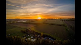
The layout of the district is clustered development in the northern half and buffered, dispersed settlement interspersed by the North Downs which is an escarpment of varied farms and woodland in the south.
- The M25 motorway bisects the district
- Swanscombe and Greenhithe have low rise homes and mid rise by the river Thames.
Housing is a mixture of relatively high rise in Dartford centre through to low rise in all of the villages.
The number of listed buildings in the district exceeds 50. This includes 7 churches listed in the highest grading in the national listing system (Grade I).
The population rose in the 10 years to 2011 from 85,911 to 97,365, by 13.3%, which was above the national average.
87.3% of residents were born in England, which was 2.5% higher than the average for the South East. The next most common group of countries of birth was the non-EU, however this was 0.3% lower than the average for the South-East and 2% lower than the average for England.
As to residents of EU birth, only 3.3% of the population were such, slightly below the national average and two-thirds of this migration was from the accession countries from 2001 to 2011, a 12.5% higher proportion than that seen nationwide.
As to older people, the borough has a below national and regional proportion. In common with most of the country, an increase in people living in their area above the age of 74 took place, whether through change in preference or most commonly longevity, from 6.5% in 2001 to 7.1% in 2011.
With 80.8% of households with a car or van, this was 6.6% above the national average, however still marginally lower than South East's record and national-high of 81.4%.
1.0% of the population lived in a communal establishment in the area.
As to homes, as 12.6% of properties in the area are detached, these form a smaller minority than the regional and national averages (at 28.0% and 22.3% of dwellings respectively).
Its people in 2011 were more economically active than the regional and national average; while self-employed inhabitants were at parity with the national average, those in full-time employment were 6.0% greater.
As to religion, statistics mirrored closely the national average, save that more Hindus and Sikhs live in the borough, at a combined, equally split 3.2% of the total population and fewer Muslims, also forming 1.6% of the population. Being almost at the mean for the country, Christians form just over 60% of the area's population.
Although many of area's traditional industries of papermaking, cement, and pharmaceuticals are in decline or closing down, and many of borough's inhabitants travel away from the borough by rail and road (many commuting to London and other areas for work), there is still a large industrial and commercial base. Included among those areas include 'The Bridge' and Crossways to either side of the Queen Elizabeth II Bridge, areas around Greenhithe and a 740-acre (3.0 km2) site planned to contain five separate 'villages' in the Eastern Quarry near Bluewater Shopping Centre, itself a large employer.
In 2012 plans were announced for the London Resort, envisaged as a major theme park to be built on the Swanscombe peninsula, which at the time was said to be able to create up to 27,000 jobs by 2018. As of 2023 no development had taken place.
There are eight civil parishes in the borough. The parish council for Swanscombe and Greenhithe has declared that parish to be a town, allowing it to take the name "Swanscombe and Greenhithe Town Council". The main part of the Dartford urban area, roughly corresponding to the pre-1974 borough, is unparished, as is the Ebbsfleet area which was removed from the parish of Swanscombe and Greenhithe in 2019. Dartford, Greenhithe, Longfield and Swanscombe are all post towns.
- Grade I listed buildings in Dartford (borough)
- Grade II* listed buildings in Dartford (borough)
- The borough website
- The Mayor of Dartford's website
- Visit Swanscombe Town Guide
Sustainable transport[edit | edit source]
The waymarked path Darent Valley Path is 19 miles (31 km) long, following the River Darent from the banks of the River Thames at Dartford through the Kent Downs Area of Outstanding Natural Beauty to the Greensand Hills above Sevenoaks. It runs through the villages of Shoreham and Otford.
The route is well served by public transport making it ideal to break into manageable walks. Railway stations are situated at Sevenoaks, Bat & Ball, Otford, Eynsford, Farningham Road, Dunton Green and Dartford, and there are many bus routes along the route.
The route is also used by National Cycle Network Route 125, which follows the same route as the footpath.
Maps
Map of the route using OpenStreetMap data - Highlighted map of Darent Valley Footpath
Environment quality[edit | edit source]
- Dartford Clean Air on facebook.com
- Dartford Litterpickers on facebook.com
Open spaces[edit | edit source]
Central Park is a formal park in the town centre, used for various community events. It comprises 26 acres (110,000 m2) of land. W
Community river action[edit | edit source]
- Darent Nature Partnership, added 14:48, 4 June 2024 (UTC)
Health and wellbeing[edit | edit source]

Ecology Island, northkentmind.co.uk
Campaigns[edit | edit source]
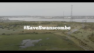
- Save Swanscombe Peninsula, added 17:32, 2 February 2022 (UTC)
- Save Swanscombe Marshes, buglife.org.uk, added 09:05, 24 December 2021 (UTC) - London Resort – a fact check buglife.org.uk, added 15:42, 24 September 2021 (UTC)
About Dartford[edit | edit source]
Dartford is the principal town in the Borough of Dartford, Kent, England. It is located 18 mi (29 km) south-east of Central London andis situated adjacent to the London Borough of Bexley to its west. To its north, across the Thames estuary, is Thurrock in Essex, which can be reached via the Dartford Crossing. To its east lies the Borough of Gravesham and to the south the district of Sevenoaks. It had a population of 51,240.
The town centre lies in a valley through which the River Darent flows and where the old road from London to Dover crossed: hence the name, which derives from Darent + ford. Dartford became a market town in medieval times and, although today it is principally a commuter town for Greater London, it has a long history of religious, industrial and cultural importance. It is an important rail hub; the main through-road now by-passes the town itself.
Near you[edit | edit source]
See also[edit | edit source]
- Towards a more democratic and climate friendly way of meeting housing need across England
- London and South East England
- Saving water in South East England
References